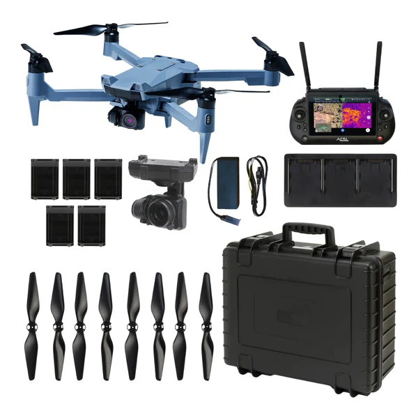
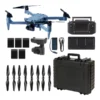
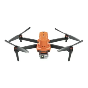
ACSL SOTEN Survey Package with TAITEN Smart Controller

$28,840.00
- Secure NDAA-compliant drone system with AES-256 encrypted communications
- Dual-band 2.4/5.8 GHz radios improve connectivity and resilience
- TAITEN Smart Controller: 7″ 1500-nit display with IP54 ruggedness
- High-resolution CX-GB100 20MP camera with mechanical shutter
- One-touch swappable payloads including thermal and multispectral options
- Multi-operator support with up to 3 controllers per aircraft
- Optional LTE connectivity and offline maps for remote areas
- FAA Remote ID-ready and ISO15408 compliant architecture
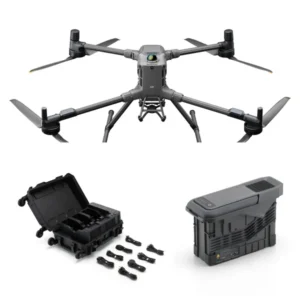
- Foldable 1.7 kg airframe with 5 included smart batteries
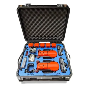
- Rugged transport case ensures secure deployment in the field
ACSL SOTEN Survey Package with TAITEN Smart Controller: Reliable Control for Secure Surveys
The ACSL SOTEN Survey Package with TAITEN Smart Controller is purpose-built for inspection and survey professionals who demand secure and accurate aerial workflows.
With NDAA compliance, AES-256 encryption, and dual-band radios, SOTEN ensures dependable performance while TAITEN provides a daylight-readable 7-inch display, rugged IP54 build, and extended runtime.
Compact and foldable, the system is designed for efficient, field-ready operations backed by Dronefly’s trusted expertise and post-sale support.
Bundle Highlights
- NDAA-compliant, AES-256 encrypted small UAS built in Japan
- TAITEN Smart Controller with 7″ 1500-nit daylight display, IP54 build
- Dual-band 2.4 GHz + 5.8 GHz comms with resilient Fides-Link
- CX-GB100 camera: 20MP resolution, 1″ sensor, mechanical shutter
- Optional LTE and offline maps for extended and disconnected ops
- One-touch swappable payload system with thermal and multispectral options
- Multi-operator pairing: up to 3 controllers per aircraft
- HDMI, USB-C, Ethernet, and microSD ports for flexible workflows
- Foldable 1.7 kg airframe with IP43 chassis for field deployment
- FAA Remote ID ready and ISO/IEC 15408 compliant
Advanced Aerial Imaging and Secure Connectivity
The package includes the CX-GB100 20MP visible camera with a mechanical shutter for high-resolution mapping and documentation.
The TAITEN Smart Controller runs ACSL’s TAKEOFF app on Android 13, integrating advanced controls and HDMI output for professional workflows.
With an unobstructed 6+ mile range and optional LTE connectivity, SOTEN supports BVLOS and remote operations where permitted.
Built for Professional Survey and Inspection Teams
Swappable payloads allow rapid mission adaptation-from visible imaging to thermal, multispectral, or zoom modules. Up to five included smart batteries extend survey endurance, while the rugged transport case simplifies secure deployment.
Multi-operator support lets teams pair up to three controllers per aircraft, ensuring flexibility in training and complex field missions.
Applications and Use Cases
- Property and land surveys: Generate accurate geospatial data securely
- Construction monitoring: Document progress and detect potential issues
- Infrastructure inspection: Assess bridges, towers, and utilities safely
- Environmental analysis: Support planning with detailed aerial data
- Utility corridor mapping: Streamline inspections of lines and pipelines
- Disaster response: Deploy in emergencies for situational awareness
- Training and team ops: Enable instructor/pilot or payload sharing
- Remote operations: LTE and offline maps support BVLOS missions
The ACSL SOTEN Survey Package with TAITEN Smart Controller offers secure, NDAA-compliant performance in a portable platform. Designed for professionals, it supports survey, inspection, and response missions with resilience and precision.
Dronefly provides end-to-end service and expert support, ensuring you maximize the performance of your ACSL system. Contact Dronefly today to equip your team with the ACSL SOTEN Survey Package with TAITEN Smart Controller.
Be the first to review “ACSL SOTEN Survey Package with TAITEN Smart Controller”
Related products

Reviews
There are no reviews yet.